
# Understanding GTFS and Its Role in Modern Public Transport Networks
Public transport systems are complex by nature. They involve multiple routes, operators, schedules, and constantly changing real-world conditions. Yet, when done right, they appear simple to the user: open an app, check a route, and move.
Behind that simplicity lies a critical standard: GTFS (General Transit Feed Specification).
# What is GTFS?
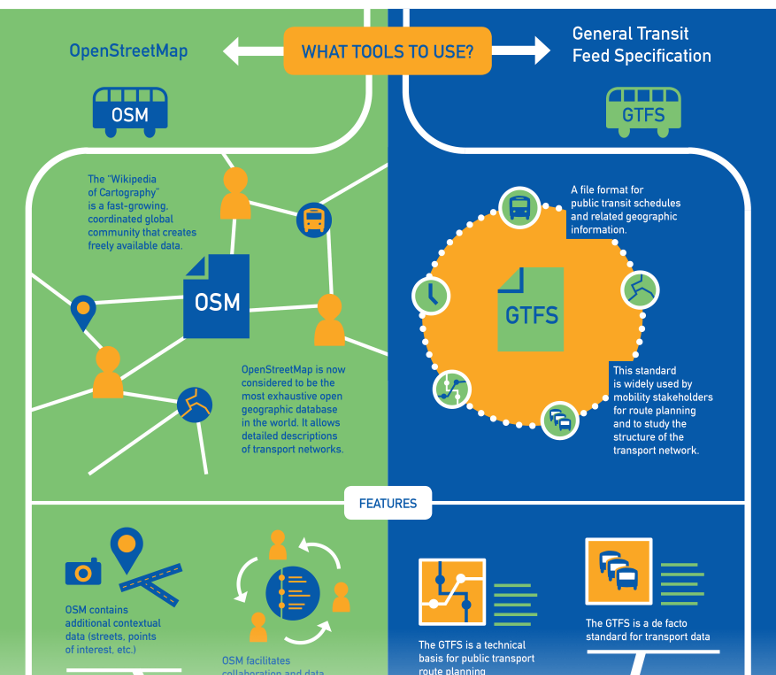 GTFS is a standardized data format used by public transport agencies to share transit information with developers, applications, and mapping services.
At its core, GTFS is a collection of structured text files (usually CSV) that describe a transport network. These files include:
- Stops (locations where passengers board or alight)
- Routes (bus lines, train lines, etc.)
- Trips (specific journeys along a route)
- Stop times (arrival and departure schedules)
- Calendars (service availability by day/date)
This structure allows any system to interpret transit data consistently.
# Why GTFS Matters
Before GTFS, every transport provider had its own proprietary format. This made integration extremely difficult.
GTFS changed that by enabling:
# 1. Interoperability
Different systems can now consume the same data format. Whether it’s a mobile app, a journey planner, or a backend optimization engine, GTFS acts as a shared language.
# 2. Ecosystem Growth
Platforms like Google Maps and other journey planners rely heavily on GTFS feeds. This has allowed even small transport agencies to become globally accessible.
# 3. Faster Development
Instead of building data models from scratch, developers can plug directly into GTFS feeds and focus on features like routing, UX, and analytics.
# Structure of a GTFS Feed
A typical GTFS dataset includes several key files:
FilePurposestops.txtDefines all stops with coordinatesroutes.txtLists all routes (e.g., Bus 23)trips.txtDefines individual journeysstop_times.txtLinks trips to stops with timingcalendar.txtSpecifies when services run
This relational structure is what enables route computation and scheduling.
# GTFS in Public Transport Networks
In a real-world public transport network, GTFS acts as the digital twin of the system.
It allows you to:
- Model the entire network graph
- Compute optimal routes (shortest time, least transfers)
- Estimate travel durations
- Analyze coverage and gaps
- Simulate improvements
For example, in a city like Nairobi, where informal systems (like matatus) dominate, structuring routes into GTFS can transform a chaotic network into something computationally usable.
# Static vs Real-Time GTFS
There are two main variants:
# GTFS Static
This is the baseline dataset:
- Fixed schedules
- Planned routes
- Regular service patterns
# GTFS Realtime
This adds live data on top:
- Vehicle positions
- Delays
- Service alerts
Together, they enable dynamic journey planning.
# Challenges in Emerging Transport Systems
While GTFS is powerful, applying it in cities with informal transport systems presents unique challenges:
- Routes may not be officially documented
- Schedules are often flexible or nonexistent
- Stops are not always fixed
- Data collection is manual and costly
However, solving these challenges creates massive value. Once structured, the network becomes:
- Searchable
- Optimizable
- Scalable
# Building on Top of GTFS
For developers and startups, GTFS is just the foundation. The real value comes from what you build on top:
- Journey planners
- Fare estimation systems
- Transport analytics dashboards
- Fleet optimization tools
- AI-based routing assistants
In your case (e.g., building a mobility product), GTFS is the layer that converts raw transport chaos into a programmable system.
Here's a piece of the script used:
'use client';

import { useTranslation } from 'react-i18next';
import { useState } from 'react';
import { Globe, Languages } from 'lucide-react';

export function LanguageSwitcher() {
  const { i18n } = useTranslation();
  const [open, setOpen] = useState(false);

  const current = i18n.language?.startsWith('fr') ? 'FR' : 'EN';

  const select = (lng: string) => {
    i18n.changeLanguage(lng);
    setOpen(false);
  };

  return (
    <div className="relative">
      <button
        type="button"
        onClick={() => setOpen(v => !v)}
        aria-expanded={open}
        aria-label="Switch language"
        className={[
          'inline-flex h-8 items-center gap-1.5 border px-2.5',
          'font-mono text-[11px] uppercase tracking-widest',
          'transition-colors duration-150 focus-visible:outline-none',
          open
            ? 'border-[#2467AC] text-[#2467AC]'
            : 'border-zinc-200 text-zinc-500 hover:border-zinc-900 hover:text-zinc-900 dark:border-zinc-800 dark:text-zinc-400 dark:hover:border-zinc-200 dark:hover:text-zinc-100',
        ].join(' ')}
      >
        <Languages className="h-3.5 w-3.5" />

        {current}
      </button>

      {open && (
        <>
          <div className="fixed inset-0 z-40" aria-hidden onClick={() => setOpen(false)} />
          <div className="absolute right-0 z-50 mt-1 w-36 border border-zinc-200 bg-white dark:border-zinc-800 dark:bg-zinc-950">
            {(['en', 'fr'] as const).map(lng => {
              const active = i18n.language?.startsWith(lng);
              return (
                <button
                  key={lng}
                  type="button"
                  onClick={() => select(lng)}
                  className={[
                    'flex w-full items-center gap-2.5 px-3 py-2.5',
                    'font-mono text-[11px] uppercase tracking-widest transition-colors',
                    active
                      ? ' hover:text-zinc-900 dark:text-zinc-400 dark:hover:bg-zinc-900 dark:hover:text-zinc-100'
                      : 'text-zinc-600 hover:bg-zinc-50 hover:text-zinc-900 dark:text-zinc-400 dark:hover:bg-zinc-900 dark:hover:text-zinc-100',
                  ].join(' ')}
                >
                  <span aria-hidden>{lng === 'en' ? '🇬🇧' : '🇫🇷'}</span>
                  {lng === 'en' ? 'English' : 'Français'}
                </button>
              );
            })}
          </div>
        </>
      )}
    </div>
  );
}
# Conclusion
GTFS is more than a data format—it’s an enabler of modern mobility systems.
It transforms public transport from a fragmented, opaque system into something structured, accessible, and scalable.
If you’re working on transport in cities like Nairobi, mastering GTFS is not optional. It’s the entry point to building anything meaningful in this space.